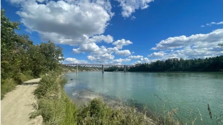
Welcome news as some areas in the province deal with flooding and high water levels. The City of Edmonton sent a public service announcement on Tuesday warning people to “exercise extreme caution around the North Saskatchewan River and its tributaries.” “Due to the continuous rain, the river, as well as shorelines and trails directly near the river, may be unsafe,” said the announcement. “Edmontonians may expect high water levels and increased current flow in the coming days. This may cause some flooding in areas running along the North Saskatchewan River and other natural waterways.”
'Exercise extreme caution': Heavy rainfall causes rising water on North Saskatchewan River
Edmontonians are being asked to “exercise extreme caution” as water levels rise on the North Saskatchewan River and its tributaries following continuous rainfall this week. City officials in a Thursday news release warned that the river, shorelines and trails directly near the river may be unsafe due to rising water levels and increased current flow following a rain storm that dumped a large amount of rain on the province over the last 24 hours. The city said flooding may occur in some areas along the North Saskatchewan River and other natural waterways.
How the health of a river is influenced by what's happening on land
For some residents of northern Alberta and Saskatchewan, the North Saskatchewan River is nothing more than a flowing body of water that starts at the Saskatchewan Glacier in Banff National Park and winds its way northeast. But it's much more than that. The river is a part of a bigger network of streams and channels that feed into it on its path through the Prairies. We're talking about a watershed — an area of land that drains into a water body.
A moment in history: Oct. 5, 1914
On this day in 1914, the City of Edmonton was under a court order to clean up its act when it came to dumping sewage into the North Saskatchewan River. The injunction had been handed down by a justice that January and meant, according to the city’s lawyer, that Edmonton would have to halt building any new sewer connections that put additional waste into the river. It also gave the city two years “to construct a proper disposal plant,” according to a short item published in an Edmonton newspaper. The story indicates that both the province and the city tried to get the injunction softened, to no avail.
Governments of Canada and Alberta officially accept nomination of the Alberta section of the North Saskatchewan River as a Canadian Heritage River
Heritage places reflect the rich and varied stories of Canada and provide an opportunity for Canadians to learn more about our diverse history. Today, the Honourable Steven Guilbeault, Minister of Environment and Climate Change and Minister responsible for Parks Canada, and the Honourable Whitney Issik, Alberta Minister of Environment and Parks, announced the official endorsement of the nomination of the North Saskatchewan River as a Canadian Heritage River.
'Bad year for the glaciers': Climate change threatens glacier behind Edmonton's water source
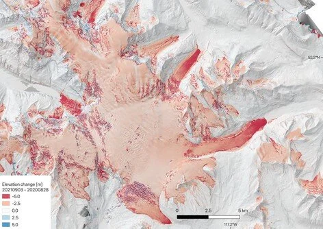
The province is long past the oppressive “heat dome” that caused cities to swelter last summer, but warmer temperatures this year had a lasting effect on the glacier that feeds Edmonton’s water supply. The Saskatchewan Glacier terminus saw 10 metres of thinning this year, said Brian Menounos, an earth sciences professor at the University of Northern British Columbia and Canada Research Chair in glacier change. It’s also the glacier that feeds the North Saskatchewan River, Edmonton’s sole source of drinking water.
Why the North Saskatchewan River has gone from brown to blue
The North Saskatchewan River looks less like chocolate milk than usual. The clear, aquamarine waters have revealed hidden sandbars, darting fish, submerged shopping carts — and a flood of questions from Edmontonians seeking clarity on the colour change. The river, which starts at the Saskatchewan Glacier in the Columbia Icefields in Alberta and flows through to central Saskatchewan, is usually a murky brown by the time it reaches Edmonton in summer.
Saskatchewan River Water Walk group hopes to raise awareness of need to protect water source
The Saskatchewan River Water Walk is continuing this week as the grassroots group heads across Saskatchewan and Alberta, raising awareness of the need for people to respect the water as a life source. The group were in the Delmas and Battlefords area recently, and will finish the walk east of Prince Albert, at the Saskatchewan River Forks. Organizer Tasha Beeds says the aim of the walk is to increase understanding of the value of the North Saskatchewan River in people’s lives, today and into the future. “It’s more about raising consciousness about the need to see that water as living, to see that all of life needs water,” she said.
Water release at Bighorn Dam will raise water levels of North Saskatchewan River: TransAlta
A planned water release at the spillway of the Bighorn Dam will raise the water level of the North Saskatchewan River and affect downstream communities, TransAlta said Tuesday. TransAlta is scheduled to begin releasing water on Thursday as part of a "proactive operation to manage water elevation" at Abraham Lake. The spillway flows into the North Saskatchewan River west of Nordegg in north-central Alberta.
Alberta moving forward on two new plans to maintain river water quality
Alberta is proposing two new plans to monitor water quality on the North Saskatchewan, Battle and Upper Athabasca rivers. Environment Minister Jason Nixon said Tuesday at a press conference in Edmonton the province will establish clear objectives to monitor and maintain water quality after public consultations. "This level of oversight helps us better understand the cumulative effects of various activities on the landscape which is essential to making informed decisions in the future about land and water management and resource development," Nixon said.
Research on Sask. rivers and streams used to predict floods and climate change
The public looks to Environment Canada to predict the weather in the sky but their work is also used to predict floods and climate change. Hydrometric technologist Cody Garbutt comes to Prince Albert every two months to collect data about the North Saskatchewan River. It’s one of 170 hydrological monitoring stations in Saskatchewan that are run by Environment and Climate Change Canada.
'An abomination': Sask. water expert warns of contamination following Alberta's coal policy changes
Alberta's plan to allow for open-pit coal mining in the Rocky Mountains could be a serious threat to Saskatchewan's water supply, says the director of the Global Water Futures Project at the University of Saskatchewan. "For a water scientist to see this happening, it's just an abomination to have these types of developments suggested in the headwaters of the rivers that supply drinking water and the economy for most of Saskatchewan," John Pomeroy told CBC's Blue Sky. Last spring, the Alberta government revoked a 1976 policy that blocked open-pit coal mining on the eastern slopes and peaks of the Rockies.
Prince Albert region taps $45 million water project
Rural communities near Prince Albert want to turn the taps on a $45 million water project. The Town of Shellbrook and the RM of Shellbrook have struck a steering committee with the Prince Albert Rural Water Utility (PARWU), spending $60,000 on studying a new water treatment plant with connecting pipelines to the communities, according to its terms of reference. “I really believe that building a water treatment plant will open the door to other communities to get good water,” noted Brent Miller, who is the steering committee chair and a Town of Shellbrook councillor.
Potential damage is being downplayed in latest Alberta oil pipeline leak
Less than two months after a spill at an oil pipeline dumped 900,000 litres of contaminated water–so called “produced water”–in northwestern Alberta, there’s been another spill in the oil-rich province. The latest spill, reported at 2 p.m on Christmas Day by a local landowner, occurred near Drayton Valley, a community about 130 kilometres southwest of Edmonton, the province’s capital city. Drayton Valley was the site of a spill–the result of a ruptured pipeline–that dumped 40,000 litres of crude oil into a local creek in August, 2019.
Pipeline spills about 400,000 litres, some enters North Saskatchewan River
Contaminated water that leaked from an oilfield pipeline on Christmas Day has entered the North Saskatchewan River but has had no detectable impact on it, says a spokesman for Calgary-based oil and gas producer ARC Resources Ltd. The spill was reported by a local landowner at about 2 p.m. last Friday, said Sean Calder, ARC's vice-president of production, in an interview on Tuesday. "We had guys on site within about an hour and then the pipeline was shut in by 4 p.m., I believe," he said.
Edmonton water sniffers poised to whiff into action with spring runoff
Amber Sears removes a glass stopper from a beaker, gives the contents a swirl and takes a whiff.
The 23-year-old is a water lab technician and sniffing is her job.
"You're smelling for musty and earthy smells," Sears said. "That's what happens when the spring runoff happens, when the vegetation comes into the water."
She checks the scent wheel which offers descriptors like fishy, swampy and flowery. The wheel helps testers like Sears circle in on the aromatic analysis of our drinking water.


