Ocean temperatures in Atlantic Canada set record highs again in 2022, according to the latest assessment released by the federal Department of Fisheries and Oceans. Results from the annual Atlantic Zone Monitoring Program show surface, intermediate and bottom temperatures were well above normal last year. "It was widespread. It was everywhere," said Peter Galbraith, a DFO research scientist in Mont-Joli, Que. "It was really, really warm across the zone."
'Waves onto my front porch'; $17M investment to prevent climate disasters in Port Stanley
Spencer Noble knows all about the flooding issues on William St. in Port Stanley, Ont. Whenever there is a large rain, he gets a few feet of water on the street in front of his home. "The water comes right up, hits the steps, and when a car comes by it sends waves onto the front porch," says Noble. “We've played in it, and even brought a canoe across the street to the bar, and boogie boarded in the road."
Why do oceans matter for climate change?
As the climate crisis gets worse, oceans — the planet’s greatest carbon sink — can no longer be overlooked. Spanning 70 per cent of the globe, oceans have absorbed nearly a third of the planet-warming greenhouse gas emissions caused by humans and 90 per cent of the excess heat those gases create. The heat stored in the Earth’s entire atmosphere is equal to what’s stored in the top few metres of our oceans. If that wasn’t enough, oceans produce more than 50 per cent of the planet’s oxygen and regulate our climate and weather patterns.
Fiercer storms and bigger waves hasten Tuk’s erosion crisis
The Northwest Territories hamlet has spent years coming up with a plan to move some homes away from its rapidly eroding coast, but the problem could be complicated by erosion of an island that currently protects Tuktoyaktuk’s harbour. With less sea ice cover, storms have more open water across which to whip up waves that can batter the community and hasten erosion.
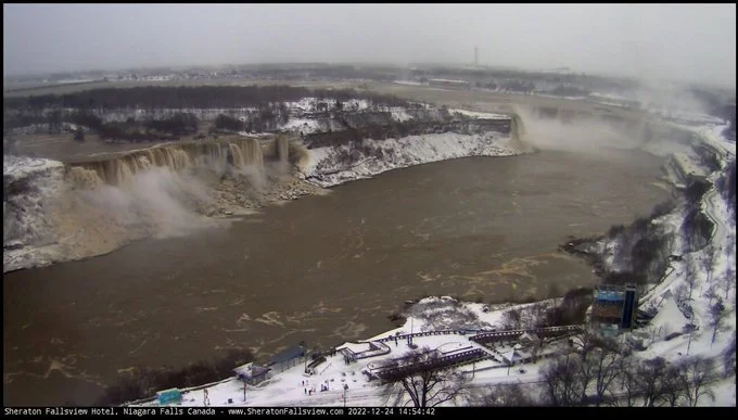
Niagara Falls turned brown on Christmas Day
Tourists visiting Niagara Falls Christmas Day saw the honourary 8th wonder of the world sporting a new look - the water had turned brown. In a tweet, ECCC Canada said the water looked "chocolate," but you wouldn't want to drink the water roaring down the falls. The temporary makeover was due to winds up to 110 km/h sweeping over Lake Erie for two days prior, coupled with harsh, 9-metre waves that churned debris. So while some of the colour was due to rocks, sand, and other natural pieces of debris some was due to storm sewer backwash emptying into the Niagara River and Fort Erie, Insauga reports.
Flood Watch Issued for Lake Erie Shoreline
A Flood Watch has been issued for Niagara's Lake Erie shoreline. With Environment Canada issuing a special weather statement, the Niagara Peninsula Conservation Authority says the strong winds in tomorrow's forecast will increase water levels and waves along the Lake Erie shoreline in Port Colborne and Fort Erie. The Ministry of Northern Development, Mines, Natural Resources and Forestry predicts that Lake Erie water levels will rise by more than four feet above current levels tomorrow.
High winds could raise water levels more than 5 feet around Lake Winnipeg, Lake Manitoba
Strong winds could cause waves and high water levels along the southern basins of Lake Manitoba and areas around Lake Winnipeg beginning on Wednesday. Affected areas include the western shoreline near Gimli, and Victoria Beach on the east side of Lake Winnipeg. Northwest winds up to 55 km/h will develop Wednesday afternoon and last until early morning on Thursday, and could raise water levels by more than five feet, Manitoba's Hydrologic Forecast Centre advised.
Strong winds, high water levels lead to flooding along western shores of Lake Winnipeg
People living in and around Gimli, Man. are cleaning up after high lake levels and heavy winds caused flooding along the western shores of Lake Winnipeg. The situation sent waves crashing onto lakefront properties and swamped some popular destinations over the weekend, prompting calls for a better warning system to respond to similar situations in the future.
'The Blob' is back: Scientists track blanket of warm water off West Coast
A large swath of warm water spanning thousands of kilometres from the Bering Sea to Mexico, nicknamed by scientists as “the Blob,” has returned to the West Coast, threatening marine life and fisheries. The Blob was christened in 2014, after a similar natural event that spanned two years devastated the salmon industry, damaged ecosystems and disrupted wildlife like whales, sea lions and crabs. “This is a massive pool… of warm water that’s in the Pacific, that is thousands of kilometres huge,” said senior climatologist for Environment Canada David Phillips on CTV’s Your Morning Tuesday. “This one stretches from the Bering Strait, the Bering Sea, right through the Gulf of Alaska, right through to California, British Columbia, and down to Mexico.”


